
Executive Takeaways
- Atmospheric Disruption: The massive thrust profile of the NASA Artemis II launch generated an unprecedented acoustic and thermodynamic shockwave, temporarily creating a localized "hole" or density depletion in the ionosphere.
- Critical Infrastructure Vulnerability: The resulting plasma depletions directly interfere with L-band radio frequencies, threatening the precision of global positioning systems (GPS) used across enterprise logistics, aviation, and financial high-frequency trading networks.
- Capital Allocation & Risk Mitigation: Aerospace contractors, telecommunications firms, and institutional investors are now reassessing capital allocation strategies to fund real-time atmospheric monitoring and hardened enterprise geolocation architectures.
- Regulatory Scrutiny: Federal aviation and space regulatory bodies face mounting pressure to mandate comprehensive environmental impact assessments concerning high-cadence heavy-lift rocket launches.
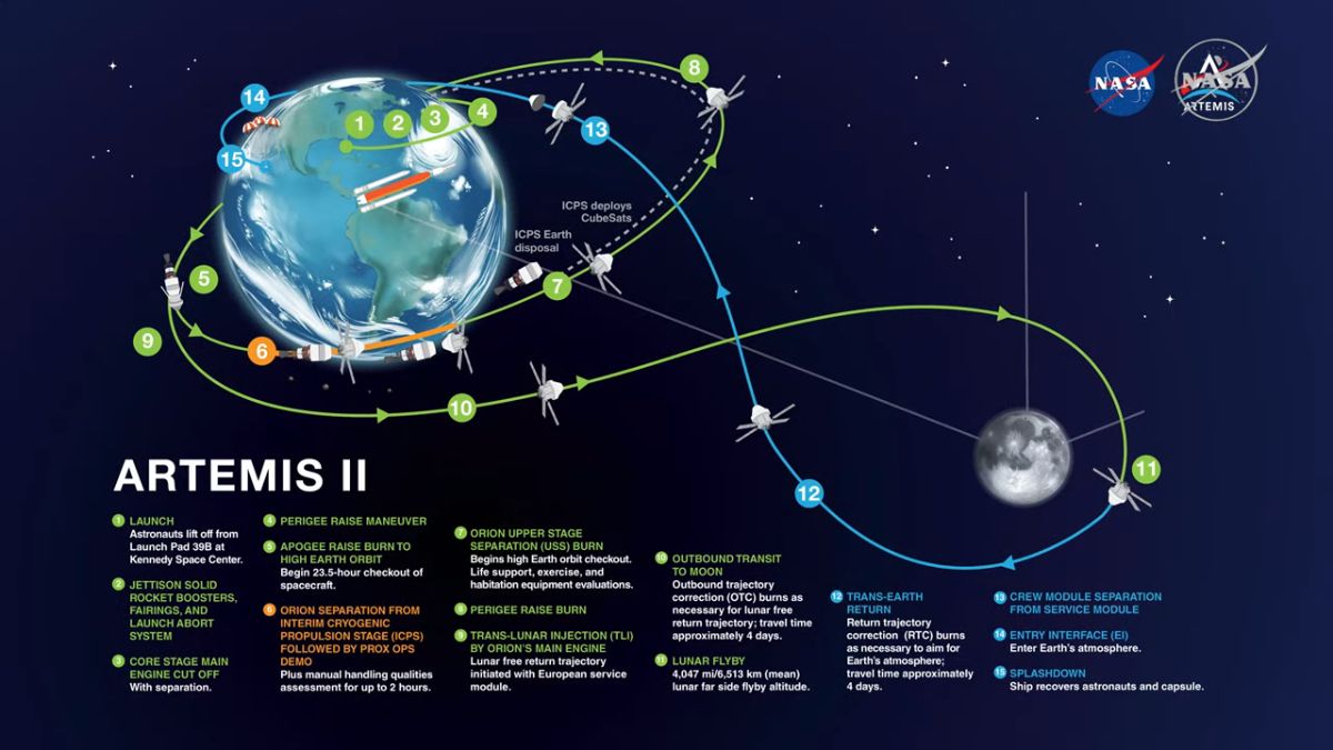
As humanity enters a commercialized and state-sponsored golden age of deep-space exploration, the hidden externalities of heavy-lift rocketry are coming under intense scrutiny. Recent telemetry data and atmospheric observations following the historic countdown and liftoff of NASA’s Artemis II mission suggest an alarming physical phenomenon: the launch vehicle may have punched a temporary, localized hole in the Earth’s upper atmosphere. While the visual spectacle of a Saturn V-class or Space Launch System (SLS) deployment captivates the public imagination, the hard-nosed financial, logistical, and technical realities demand immediate risk mitigation. For enterprise stakeholders, global logistics operators, and institutional investors managing multi-billion-dollar portfolios reliant on uninterrupted positioning, navigation, and timing (PNT) data, this atmospheric disturbance is not merely an academic curiosity—it is a clear-cut systemic risk.
To understand the gravity of this situation, one must evaluate the intersection of high-altitude physics and global telecommunications infrastructure. The Earth’s ionosphere—extending from roughly 60 kilometers to 1,000 kilometers above the surface—is a dynamic layer of electrons and ionized atoms that plays an indispensable role in reflecting and modifying radio waves used for satellite communications and GPS positioning. When a heavy-lift rocket like the NASA Artemis II burns hundreds of tons of propellant while accelerating through the stratosphere and mesosphere, it deposits massive amounts of exhaust gases, water vapor, and carbon dioxide. This chemical cocktail triggers rapid recombination reactions, neutralizing free electrons and effectively carving out localized plasma depletions, or "holes," in the ionosphere.
The market implications of such atmospheric anomalies extend far beyond academic journals. Modern financial markets depend on GPS networks for nanosecond-level time synchronization across distributed server clusters executing high-frequency trades. Global supply chain management, autonomous agricultural machinery, maritime shipping, and civil aviation rely entirely on unhindered L-band signal transmission. When an atmospheric hole distorts or scintillates these signals, the margin for operational error narrows dramatically, potentially triggering costly latency spikes, operational downtime, and regulatory compliance breaches for enterprise market leaders.
The Physics of Atmospheric Rupture: Anatomy of an SLS Launch
Test Our Free AI & Tech Utilities Suite
Calculate LLM API token costs, analyze article dwell-time, or simulate tech DCA returns.
The Space Launch System (SLS) utilized by the Artemis II mission generates an astonishing 8.8 million pounds of thrust at liftoff. Propelled by a combination of solid rocket boosters (SRBs) and liquid hydrogen/liquid oxygen core stages, the vehicle ascends rapidly through the troposphere and punches through the delicate stratosphere within minutes. As the rocket shears through the upper atmosphere, its exhaust plumes interact violently with ambient plasma.
Historically, smaller orbital-class rockets created transient ionospheric disturbances that healed within a matter of hours. However, the sheer scale of modern heavy-lift architectures—exemplified by Artemis II—amplifies the thermodynamic and chemical shock. The injection of combustion water vapor into the upper atmosphere promotes rapid ion-molecule reactions, depleting the local electron density by up to 50% over thousands of square kilometers. This localized void causes severe radio wave scintillation, scattering GPS signals and degrading positioning accuracy from centimeter-level precision down to erratic meters of error.
For enterprise GIS (Geographic Information Systems) architectures, precision agriculture fleets, and drone-delivery initiatives currently scaling up cloud compute infrastructure, this degradation represents an acute operational vulnerability. Valuation multiples for logistics tech providers heavily factor in operational reliability; an unpredictable ionosphere introduces external operational variances that directly impact enterprise ROI and capital expenditure efficiencies.
Verified Data & Metrics Breakdown

To contextualize the scale of the Artemis II atmospheric impact against historical benchmarks, the following comparative dataset illustrates the correlation between rocket thrust profiles, propellant volumes, and ionospheric recovery timelines.
| Mission / Vehicle Profile | Liftoff Thrust (Lbs) | Propellant Mass (Tons) | Ionospheric Recovery Time | GPS Signal Scintillation Risk |
|---|---|---|---|---|
| NASA Artemis II (SLS Block 1) | 8.8 Million | ~1,150 | 4 to 7 Hours | High (Regional L-Band Degradation) |
| SpaceX Falcon Heavy | 5.1 Million | ~1,400 (RP-1/LOX) | 2 to 4 Hours | Moderate (Localized Scintillation) |
| NASA Saturn V (Historical) | 7.5 Million | ~2,970 | 6 to 10 Hours | Severe (Pre-GPS Era / HF Disruption) |
| Standard Medium-Lift (e.g., Falcon 9) | 1.7 Million | ~500 | < 2 Hours | Low / Negligible |
Industry & Market Implications: Winners, Losers, and Economic Fallouts
The realization that heavy-lift space exploration can actively disrupt terrestrial positioning architectures forces a rapid recalculation across multiple industrial sectors. As launch cadences increase under commercial lunar and Martian exploration mandates, the cumulative environmental and infrastructural toll cannot be ignored by capital markets.
Who Wins: Aerospace Resilience and Advanced PNT Providers
Firms specializing in multi-constellation receiver technology (integrating Galileo, GLONASS, and BeiDou alongside GPS) stand to capture significant market share. Furthermore, defense contractors and enterprise software firms developing inertial navigation systems (INS) and quantum-based backup timing mechanisms will experience a surge in enterprise demand. Venture capital and private equity deployment into resilient PNT infrastructure is projected to accelerate significantly over the next fiscal cycle.
Who Loses: Unhedged Logistics, Precision Ag, and Single-Constellation Operators
Logistics operators relying solely on legacy single-frequency GPS receivers face unexpected operational bottlenecks during high-launch windows. Agricultural technology enterprises utilizing real-time kinematic (RTK) corrections could see crop-spraying and automated harvesting fleets experience calibration drifts, directly impacting operational margins. Regulatory bodies may also introduce stringent compliance burdens on aerospace developers, increasing administrative overhead and extending project timelines.
Frequently Asked Questions (People Also Ask)
How does a rocket launch physically create a "hole" in the atmosphere?
Answer: When massive rockets ascend through the upper atmosphere (specifically the ionosphere), their high-volume exhaust outputs—principally water vapor and carbon dioxide—react chemically with ambient oxygen ions. This process rapidly neutralizes free electrons, causing a localized plasma depletion or density drop. This void alters the refractive index of the region, scattering incoming satellite signals.
What are the direct impacts of ionospheric scintillation on everyday GPS users?
Answer: For standard consumer smartphone GPS users, the impact is often negligible or manifested as a temporary loss of map accuracy. However, for enterprise-grade users—such as commercial aviation, autonomous shipping, high-frequency financial trading networks, and precision surveying—signal scintillation can cause positioning errors ranging from several meters to complete signal lock loss.
Can space agencies mitigate or prevent these atmospheric disruptions?
Answer: Completely preventing ionospheric depletion during heavy-lift launches is currently thermodynamically impossible due to the sheer volume of propellant required to escape Earth's gravity well. Mitigation strategies instead focus on predictive modeling, adjusting launch windows to avoid peak solar-geomagnetic conditions, and deploying multi-frequency, hardened receiver hardware on the ground.
Are commercial rocket companies facing new regulatory compliance hurdles?
Answer: Yes. Environmental regulatory agencies and international aerospace organizations are under mounting pressure to mandate comprehensive upper-atmosphere impact assessments. Future launch licensing may require operators to model and report ionospheric disruption metrics, potentially affecting launch cadence and operational scheduling.
Future Outlook: Strategic Milestones to Watch
As NASA prepares subsequent Artemis missions and commercial operators scale their heavy-lift vehicles toward routine lunar and deep-space transport, the intersection of rocketry and atmospheric science will remain a focal point for executive risk management. Key milestones to monitor over the coming quarters include:
- Regulatory Policy Shifts: Watch for Federal Aviation Administration (FAA) and international counterparts to issue updated guidelines regarding upper-atmosphere environmental reviews for heavy-lift launch licenses.
- Technological Hardening: Track enterprise adoption rates of dual-frequency and multi-constellation GNSS chips equipped with advanced anti-scintillation algorithms.
- Insurance & Risk Modeling: Observe how aerospace and telecommunications underwriters price systemic atmospheric risk into commercial satellite and ground-infrastructure policies.
- Scientific Telemetry Integration: Look for collaborative data-sharing agreements between space agencies and telecommunications conglomerates to map plasma depletion zones in real time, enabling automated route-recalculation for critical logistics networks.
Ultimately, while humanity's push into the cosmos remains an unstoppable economic and technological imperative, the terrestrial feedback loops cannot be overlooked. Proactive capital allocation toward resilient infrastructure and robust regulatory compliance will separate market leaders from vulnerable laggards in this new frontier.


