
Executive Takeaways
- Capital Infusion & Valuation: Pixxel’s aggressive scaling is backed by over $100 million in cumulative venture capital, positioning the hyperspectral imaging pioneer for massive enterprise infrastructure expansion.
- Technological Paradigm Shift: Moving beyond conventional RGB and multispectral imaging, Pixxel’s proprietary satellites capture hundreds of narrow spectral bands, transforming raw data into actionable enterprise ROI.
- Global Market Disruption: By democratizing high-resolution chemical and material identification from low Earth orbit (LEO), Pixxel is forcing legacy aerospace defense contractors and traditional geospatial firms to reevaluate their capital allocation and cloud compute architectures.
For decades, commercial Earth observation has been dominated by a relatively simple visual premise: take pictures of the Earth from space, stitch them together, and sell them to governments, mapmakers, and agricultural conglomerates. Yet, looking at a blue marble or a green canopy tells an incomplete story. It reveals where a forest stands, but not whether it is succumbing to disease. It shows a vast expanse of desert, but misses the subsurface mineral deposits hidden beneath the dust. It captures a river delta, but remains blind to the chemical composition of industrial runoff.
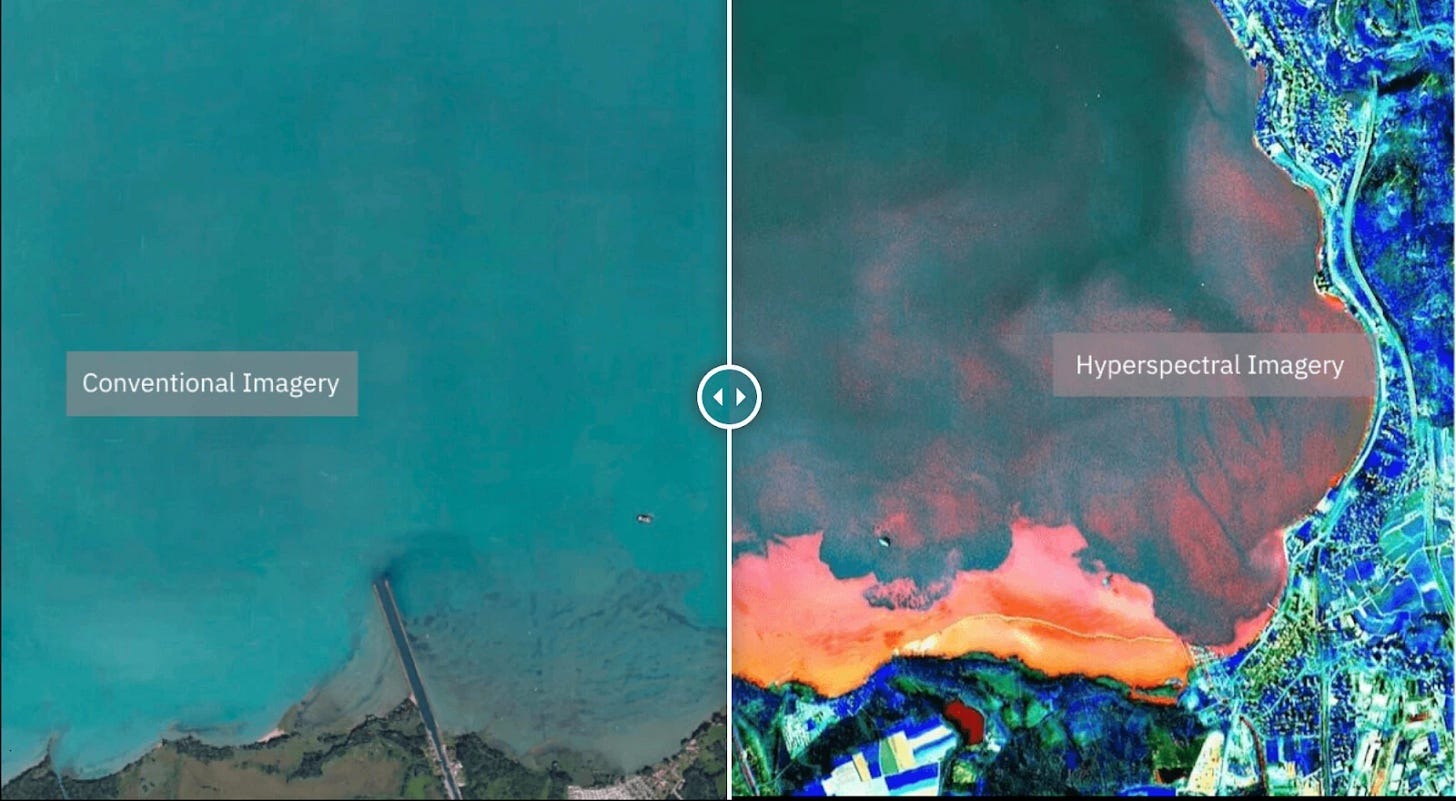
Enter Awais Ahmed and the team at Pixxel. Founded when Ahmed was barely out of his teens, the Bengaluru- and Los Angeles-headquartered aerospace startup has quietly engineered one of the most significant leaps in remote sensing technology of the 21st century: hyperspectral imaging from space. By capturing data across hundreds of contiguous spectral bands—far beyond the human eye’s capacity or traditional three-band satellite imagery—Pixxel is shifting the paradigm from merely seeing the Earth to fundamentally understanding its chemical and biological makeup.
Following a successful capital raise crossing the $100 million threshold in total funding, Pixxel is no longer just an ambitious deep-tech experiment. It is transforming into a full-scale commercial utility, testing the limits of orbital logistics, cloud compute architecture, and enterprise software integration. For institutional investors, venture capitalists, and global enterprise leaders, the question is no longer whether hyperspectral technology works, but how quickly it can scale to capture a multi-billion-dollar total addressable market.
The Technological Leap: Why Hyperspectral Imaging Changes Everything
To understand the gravity of Pixxel’s market positioning, one must examine the limitations of legacy remote sensing. Traditional commercial satellites typically operate in the red, green, blue (RGB) and near-infrared spectra. While sufficient for urban planning and basic cartography, these systems suffer from a severe lack of spectral resolution. They provide pictures, not data.
Hyperspectral imaging, by contrast, records light across hundreds of narrow, continuous spectral bands. Every element, mineral, chemical compound, and biological species reflects and absorbs light in a unique, highly specific wavelength pattern—effectively a chemical fingerprint. Pixxel’s proprietary constellation is designed to read these signatures from low Earth orbit (LEO) with unprecedented spatial and radiometric fidelity.
"We are moving from an era of qualitative observation to an era of quantitative verification," notes a senior aerospace analyst based in New York. "When an enterprise can measure methane leaks down to the individual pipeline valve, or assess soil nitrogen content globally on a weekly basis, the enterprise ROI shifts from speculative risk mitigation to absolute operational certainty."
This capability is underpinned by complex engineering constraints. Processing hyperspectral imagery requires colossal bandwidth, sophisticated onboard calibration, and immense cloud compute architectures to ingest, normalize, and distribute petabytes of raw orbital data. Pixxel’s software-defined satellites and proprietary analytics platform, Aurora, are purpose-built to bridge this gap, translating raw spectral cubes into user-ready intelligence layers for enterprise clients.
Capital Allocation, Infrastructure Scalability, and Market Traction

Building hardware that operates in the harsh radiative environment of LEO is notoriously capital-intensive. Historically, hardware-heavy space ventures have struggled with high capital expenditure (CapEx) burn rates, elongated deployment timelines, and fragile supply chains. Pixxel’s financial strategy has balanced aggressive constellation deployment with rigorous risk mitigation.
Securing a cumulative war chest exceeding $100 million through rounds backed by prominent global venture funds and strategic investors has allowed Pixxel to accelerate its manufacturing cadence. The company’s phased roadmap involves deploying a constellation of commercial satellites capable of daily global coverage. This high revisit rate is the holy grail for enterprise clients who require real-time monitoring rather than archival snapshots.
| Metric / Parameter | Legacy Multispectral Systems | Pixxel Hyperspectral Constellation |
|---|---|---|
| Spectral Bands | 3 to 10 broad bands | Hundreds of narrow, contiguous bands |
| Primary Use Case | Mapping, visual navigation, broad land-use | Chemical identification, mineral exploration, ESG tracking |
| Data Processing | Standard GIS software / manual analysis | Cloud-native AI/ML pipelines (Aurora platform) |
| Global Revisit Rate | Varies (often 3 to 14 days) | Targeted daily global hyperspectral monitoring |
This infrastructure scalability is directly linked to market liquidity and valuation multiples in the private markets. While many space tech startups faced valuation contractions during broader macroeconomic corrections, deep-tech firms demonstrating clear, enterprise-grade utility and recurring software-as-a-service (SaaS) revenue models continue to command premium pricing.
Industry & Market Implications: Who Wins and Who Loses
The maturation of Pixxel’s technology sends shockwaves across multiple verticals, altering competitive dynamics from energy to agriculture.
- Energy & Utilities (The Winners): Oil, gas, and renewable energy conglomerates face mounting regulatory compliance pressures and ESG reporting mandates. Pixxel’s ability to pinpoint methane leaks and monitor environmental degradation in real time offers a powerful tool for avoiding regulatory fines and mitigating catastrophic environmental liabilities.
- Agriculture & Agtech (The Innovators): Precision farming moves from a buzzword to a balance-sheet driver. By analyzing soil moisture, nitrogen levels, and crop stress at a molecular level, agribusinesses can optimize fertilizer usage, boost yields, and hedge against climate volatility.
- Legacy Geospatial Providers (The Disrupted): Traditional satellite imaging companies that rely solely on optical RGB sensors face an existential threat. Unless they acquire or develop advanced hyperspectral capabilities, their product offerings risk commoditization against high-fidelity chemical intelligence.
- Defense & Intelligence Agencies (Strategic Buyers): Governments worldwide are increasingly turning to commercial space assets to supplement classified national security networks. Pixxel’s capacity to detect camouflage, monitor subterranean resource extraction, and assess environmental security provides critical geopolitical leverage.
Frequently Asked Questions (People Also Ask)
What is hyperspectral imaging and how does it differ from regular satellite photography?
While standard satellite photography captures light in three primary colors (Red, Green, Blue) much like a consumer digital camera, hyperspectral imaging captures light across hundreds of continuous, narrow spectral bands. This allows satellites to detect the unique chemical and material fingerprints of objects on Earth, enabling users to identify specific minerals, vegetation health, and chemical emissions remotely.
How does Pixxel plan to monetize its satellite constellation?
Pixxel operates on a data-as-a-service (DaaS) and software-as-a-service (SaaS) business model. The company monetizes its constellation by selling subscription-based access to its high-resolution hyperspectral datasets and analytics platforms to enterprise clients across agriculture, energy, mining, and government defense sectors.
What is the significance of Pixxel raising over $100 million in funding?
Crossing the $100 million funding threshold marks a critical transition point for Pixxel, moving it from an R&D-focused startup into a commercially viable enterprise. This capital allows the company to accelerate satellite manufacturing, expand its global ground station network, scale its cloud compute infrastructure, and aggressively pursue enterprise sales contracts worldwide.
Which industries stand to benefit the most from Pixxel’s hyperspectral data?
The primary beneficiaries include agriculture (for precision crop management), energy and utilities (for methane leak detection and pipeline monitoring), mining (for subsurface mineral exploration), and government/environmental agencies (for climate tracking, disaster response, and regulatory compliance).
Future Outlook: Milestones on the Horizon
As Pixxel enters its next phase of growth under Awais Ahmed’s leadership, the focal point shifts from technical proof-of-concept to relentless commercial execution. Key milestones to watch over the next 12 to 24 months include the successful launch of subsequent operational satellites, the expansion of enterprise distribution partnerships, and the integration of advanced machine learning models into the Aurora analytics suite.
In an increasingly resource-constrained and climate-volatile world, the ability to monitor the Earth’s health with surgical precision is no longer a luxury—it is an economic and ecological imperative. By bridging the gap between orbital hardware and enterprise intelligence, Pixxel is proving that looking at the Earth is no longer enough. To survive and thrive, we must understand it down to the last wavelength.