
Executive Takeaways
- The Paradigm Shift: Pixxel, led by co-founder and CEO Awais Ahmed, is engineering an orbital transition from spatial imaging to molecular-level hyperspectral analysis, shifting the sector's benchmark from mere Earth observation to automated, algorithmic Earth understanding.
- Capital Infusion: Approaching the $100 million cumulative capitalization threshold—anchored by strategic backing from Alphabet (Google), Radical Ventures, and Lightspeed—the deep-tech enterprise is transitioning from orbital validation to hyperscale enterprise monetization.
- Enterprise ROI & Unit Economics: By capturing up to 300 contiguous spectral bands compared to standard 3-band to 8-band commercial imagery, Pixxel offers multi-billion-dollar visibility pipelines to extractives, industrial agriculture, and sovereign defense apparatuses.
- Verticalized Platform Strategy: The launch of proprietary analytics layer "Aurora" transforms raw gigabits into high-margin SaaS subscriptions, mitigating the traditional satellite commodity trap and challenging legacy aerospace pricing power.
For more than half a century, the commercial remote sensing industry operated under a singular, capital-intensive dogma: higher spatial resolution was the definitive commercial frontier. From government-grade reconnaissance assets to the commercial constellations launched by DigitalGlobe, Maxar Technologies, and Planet Labs, the primary objective was sharpening the Earth’s pixels—advancing from ten-meter granularity down to the sub-30-centimeter threshold where individual vehicle license plates skirt the edge of recognition.
Yet for modern enterprise balance sheets, optical acuity has yielded diminishing marginal returns. Knowing that an open-pit mine exists, or that an agricultural monoculture spans a million hectares, no longer provides alpha to institutional commodity desks, sovereign wealth managers, or multinational extractives. The mission-critical question has shifted from where an asset is to what that asset is composed of beneath the surface veil.
Enter Pixxel. Co-founded in 2019 by then-undergraduates Awais Ahmed and Kshitij Khandelwal out of the Birla Institute of Technology and Science (BITS), Pilani, the Bengaluru- and Los Angeles-headquartered space-tech upstart is executing an aggressive push to render traditional multispectral Earth observation obsolete. By deploying a commercial constellation of high-resolution hyperspectral satellites, Pixxel captures invisible electromagnetic signatures that expose internal crop diseases, subterranean hydrocarbon leaks, heavy-metal concentration in mining tailings, and subtle greenhouse gas dispersals long before standard sensors detect a trace.
With an aggregate capital structure approaching $100 million—underwritten by premier institutional investors alongside strategic capital from Google—Pixxel is not merely building a satellite constellation; it is constructing an autonomous diagnostic engine for the global economy.
The Technical Leap: Beyond the RGB Visual Trap

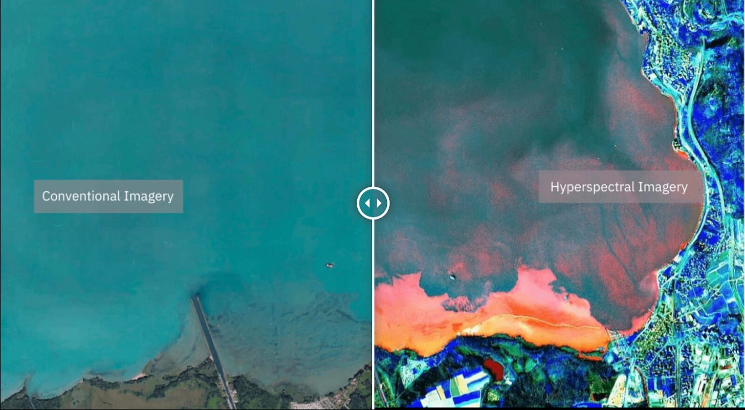
To quantify Pixxel’s disruptive potential, one must deconstruct the physics governing space-based optical payloads. The human eye, alongside standard commercial satellite optical sensors, operates across three broadband slices of the visible electromagnetic spectrum: Red, Green, and Blue (RGB), occasionally augmented by an uncalibrated near-infrared (NIR) channel. These systems aggregate vast swaths of reflected light into broad buckets, averaging out thousands of micro-variations.
Hyperspectral imaging breaks this limitation. Instead of three discrete color buckets, Pixxel’s sensors dissect reflected solar energy across hundreds of narrow, continuous spectral bands spanning the visible, near-infrared, and short-wave infrared (SWIR) wavelengths. Every material—whether it is chlorosis in an early-stage soybean field, a subterranean pipeline seep of liquid propane, or lithium-bearing spodumene crystals—possesses a distinct, irreproducible chemical absorption spectrum.
Historically, hyperspectral sensors were relegated to massive, multi-ton government apparatuses like NASA’s airborne AVIRIS or the Italian Space Agency’s PRISMA satellite. The instruments were prohibitively expensive, thermally inefficient, and produced crushing data payloads that overwhelmed satellite downlinks and edge compute capacity. Pixxel’s engineering breakthrough lies in miniaturization: integrating high-performance optical payloads into a smallsat form factor (the 50-to-100-kilogram class) while preserving optical fidelity, high signal-to-noise ratios (SNR), and high revisit rates.
The company’s pathfinder missions—including Shakuntala (TD-2), launched aboard a SpaceX Falcon 9 Transporter rideshare mission in April 2022, and Anand, hoisted by the Indian Space Research Organisation's (ISRO) PSLV later that year—validated the core thesis. Pixxel proved that commercially viable, high-SNR hyperspectral payloads could survive launch mechanical stress, maintain orbit-thermal equilibrium, and stream raw spectral data directly into commercial ground networks at attractive unit economics.
The $100 Million Balance Sheet: De-risking Deep Tech
Deep-tech space ventures frequently stall in what venture capitalists term the "orbital valley of death"—the capital-intensive chasm between prototyping a functional payload and scaling manufacturing to achieve a profitable orbital revisit cadence. Building, launching, insuring, and downlinking data from space requires high capital allocation upfront, often years before high-margin enterprise ARR (Annual Recurring Revenue) materializes.
Pixxel’s navigation of this liquidity risk has defied prevailing macro headwinds. Following a $25 million Series A round in early 2022 led by Radical Ventures, the company secured an infusion of $36 million in Series B financing in mid-2023. Notably, this round brought Alphabet into Pixxel’s capital structure as a lead strategic investor, joined by prominent institutional allocators including Lightspeed India, Blume Ventures, and Sparta Group. This tranche propelled total capitalization within striking distance of the nine-figure mark ($100M), providing runway through the operational commercialization of its flagship "Fireflies" constellation.
The strategic involvement of Alphabet warrants rigorous examination. For Google, the investment is not a passive venture play. It intersects directly with the hyperscaler's cloud infrastructure and AI strategic objectives. The operational payload of a 24-satellite hyperspectral constellation produces petabytes of dense, high-dimensional tensor data daily. Processing these feeds requires distributed computing, machine-learning-driven radiative transfer modeling, and advanced atmospheric correction pipelines—compute workloads natively suited for Google Cloud Platform (GCP). In exchange, Pixxel unlocks a planetary data-distribution pipeline through GCP’s enterprise geospatial ecosystem, instantly bypassing legacy enterprise sales cycles.
Capital Asset Benchmarking: The Satellite Infrastructure Landscape
The Earth observation (EO) market is separating into commoditized visual imaging layers and specialized analytical datasets. The following matrix contrasts Pixxel’s capital and operational profile against legacy and modern orbital imaging paradigms:
| Operator / Platform | Primary Sensor Modality | Spectral Bands | Average Spatial Resolution | Constellation Capital Intensity | Core Enterprise Revenue Driver |
|---|---|---|---|---|---|
| Pixxel (Fireflies) | Commercial Hyperspectral | Up to 300 continuous bands | 5m class | Low-to-Medium (Smallsat form factor) | Chemical/biochemical anomaly detection, ESG, mining exploration |
| Maxar Technologies (WorldView) | Very High-Resolution (VHR) Optical | 8–16 panchromatic/multispectral | 0.3m (Sub-meter) | Extremely High (Bespoke heavy satellites) | Defense & intelligence reconnaissance, sovereign mapping |
| Planet Labs (Pelican / Dove) | High-Revisit Multispectral | 4–8 discrete bands | 3m–5m | Medium (Mass-manufactured cubesats) | Macro landscape monitoring, broad-acre agriculture, defense change-detection |
| Copernicus (ESA Sentinel-2) | Public Sector Multispectral | 13 discrete bands | 10m–60m | Government / Taxpayer Funded | Free open-access scientific, environmental, academic baseline data |
From Hardware Carrier to Algorithmic Monolith: Project Aurora
Satellite hardware, regardless of how specialized its physics may be, risks rapid commoditization if restricted to wholesale data-brokerage models. The historical bankruptcies and restructurings across the space sector underscore this reality: selling raw GeoTIFF files or radiance values to end-users imposes severe friction. Corporate procurement teams rarely possess in-house PhD-level spectral scientists capable of decomposing raw SWIR absorption profiles into actionable risk assessments.
Recognizing this market failure, CEO Awais Ahmed has steered Pixxel toward a vertical software model through its proprietary geospatial data platform, Aurora. Aurora abstracts away the underlying orbital physics, functioning as an AI-driven translation engine that converts multidimensional spectral cubes into immediate, actionable operational intelligence.
The enterprise ROI calculations enabled by this platform are concrete:
- Agriculture & AgTech: Instead of estimating plant health based on the broad normalized difference vegetation index (NDVI)—which only flags stress once leaves turn yellow and cellular death has occurred—hyperspectral analytics measure nitrogen uptake, moisture content, and fungal presence at the molecular level, weeks before visual decay manifests. This allows industrial agribusinesses to optimize pesticide application, reduce input expenditures, and safeguard yields.
- Extractives & Critical Minerals: The global transition to electrification has ignited a fierce scramble for critical minerals such as lithium, copper, nickel, and rare earth elements. Traditional ground-based exploratory drilling costs millions of dollars per square kilometer with low hit rates. Pixxel’s sensor suite maps surface-level spectral signatures of alteration minerals, cutting target-generation timelines from quarters to days while slashing exploratory capital expenditure.
- Energy & Sovereign Emissions Compliance: With the imposition of regulatory enforcement mechanisms such as the European Union's Carbon Border Adjustment Mechanism (CBAM) and strict SEC climate disclosure rules, point-source methane leaks and industrial fugitive emissions represent material legal liabilities. Hyperspectral instruments are uniquely equipped to isolate the distinct narrow-band absorption signatures of methane (CH4) and carbon dioxide (CO2), transforming environmental compliance from self-reported estimates to unassailable physical measurement.
Market Dynamics: Winners and Losers in the Hyperspectral Transition
As Pixxel launches its operational commercial constellation, the downstream tremors will realign enterprise valuations across the geospatial analytics value chain.
The Winners:
- Commodity Trading Houses & Quantitative Hedge Funds: Proprietary access to real-time, global chemical monitoring provides an informational moat. Trading desks can evaluate aggregate yield health, grain protein metrics, and supply disruption long before official government harvest estimates or market surveys hit Bloomberg terminals.
- Mining & Critical Materials Developers: Mid-cap and junior exploration companies can optimize their capital allocation strategies by licensing localized hyperspectral packages, bypassing weeks of grueling aerial survey operations and streamlining their pre-feasibility capital deployments.
- Insurance & Reinsurance Underwriters: Parametric insurance models rely on clear, unalterable triggers. By utilizing hyperspectral ground-truth data, reinsurers can automate claim settlements for drought, pestilence, or industrial contamination with absolute mathematical finality, compressing loss-adjustment expense ratios.
The Disrupted:
- Traditional Airborne Survey Fleets: The legacy ecosystem of piloted aircraft and fixed-wing drones equipped with hyperspectral pods faces structural dislocation. While airborne systems retain an advantage in ultra-localized, ultra-high-resolution surveys, they cannot match the continuous revisit cadence, sovereign access, and negligible marginal cost per square kilometer offered by an orbital constellation.
- Pure-Play Multispectral Data Brokers: Operators reliant on basic multi-band imagery will find themselves trapped in a price-deflation spiral. As hyperspectral constellations scale and resolution parity is reached, simple 4-band visible-light data will rapidly lose pricing power, relegated to background mapping applications.
People Also Ask (Frequently Asked Questions)
How does Pixxel’s hyperspectral technology differ from Planet Labs or Maxar?
While legacy providers like Maxar excel in spatial resolution (pinpointing extremely small objects via high-resolution RGB imagery) and Planet Labs excels in high-cadence multispectral imaging (scanning the globe daily across 4 to 8 color bands), Pixxel specializes in spectral depth. Pixxel captures hundreds of narrow, continuous spectral bands across the visible, near-infrared, and short-wave infrared spectrums. This enables Pixxel to detect the chemical, biological, and mineral composition of an object—such as water stress, soil nutrients, methane leaks, or specific mineral deposits—rather than simply snapping an optical photograph of its physical geometry.
What is Pixxel’s current funding status and who are its primary investors?
Pixxel has raised close to $100 million in aggregate private venture and strategic funding. Its capital structure is anchored by a significant Series B funding round that included Alphabet (Google) as a lead strategic backer, alongside major venture capital firms such as Radical Ventures, Lightspeed India, Blume Ventures, growX ventures, and prominent institutional angel vehicles like Sparta Group. This capital directly finances constellation manufacturing, launch service contracts, ground-station infrastructure expansion, and the development of its Aurora analytics software platform.
How does Pixxel monetize its raw satellite data?
Pixxel operates a dual-pronged commercial model consisting of traditional data-as-a-service (DaaS) access and an integrated software-as-a-service (SaaS) platform known as Aurora. While government defense agencies and institutional research laboratories purchase raw, radiometrically and atmospherically corrected hypercubes, the company captures high-margin enterprise accounts by packaging spectral outputs into automated analytical subscriptions. Enterprise clients in agriculture, mining, oil and gas, and ESG compliance pay recurring license fees to access targeted alerts, composition maps, and automated risk scoring rather than processing raw imagery in-house.
What are the primary execution risks confronting Pixxel's business model?
The primary execution risks include launch deployment cadence dependencies (relying on commercial launch providers like SpaceX), orbital longevity of smallsat payloads, high computational costs for processing high-dimensional data streams, and long enterprise sales cycles. Furthermore, hyperspectral data volumes require significant data compression at the edge and substantial ground-station downlink throughput, necessitating flawless coordination between Pixxel's space segment and its terrestrial cloud processing pipelines.
Future Outlook: The Industrialization of Orbital Intelligence
The road ahead for Pixxel hinges entirely on launch cadence, orbital yield, and platform adoption. The enterprise is currently deploying its commercial constellation, "Fireflies." These 5-meter-resolution hyperspectral satellites represent a decisive operational leap over the company's early tech-demonstrator hardware, unlocking daily revisits over critical industrial, agricultural, and mineral assets.
The long-term play, however, extends beyond purely commercial enterprise tiers. Pixxel has steadily deepened its engagement with sovereign defense and intelligence apparatuses, securing an exploratory contract under the U.S. National Reconnaissance Office (NRO) Strategic Commercial Enhancements program. As geopolitical friction points escalate globally, defense organizations require continuous spectral identification to distinguish tactical camouflage from dense canopy, identify high-explosive residue, and monitor strategic materials processing behind non-transparent borders.
If Pixxel successfully scales its orbital architecture to full maturity, Awais Ahmed and his team will have engineered more than an Indian space-tech success story. They will have constructed an indispensable, real-time planetary spectrometer—a pervasive operational layer that underpins global resource management, monitors climate compliance with unyielding precision, and establishes a formidable analytical monopoly over Earth’s invisible electromagnetic spectrum.