
Executive Takeaways
- The Strategic Paradigm Shift: Pixxel is transitioning from a capital-intensive space hardware operator to a high-margin predictive analytics sovereign, transforming raw 5-meter hyperspectral orbital feeds into actionable enterprise diagnostic intelligence.
- Capital Allocation Milestones: Bolstered by backing from Google, Radical Ventures, and Lightspeed, the space-tech pioneer’s cumulative capital base is converging on the $100 million threshold, accelerating the mass-production and deployment of its enterprise-grade "Fireflies" constellation.
- Unlocking Invisible Economic Fundamentals: By capturing up to 300 contiguous spectral bands across the electromagnetic spectrum, Pixxel’s sensor suite isolates invisible commercial risks—such as pipeline fugitive methane emissions, internal crop pathogen stress, and high-grade mineral deposits—long before traditional multispectral sensors detect degradation.
- Disrupting Legacy Earth Observation: The commercialization of affordable, high-revisit hyperspectral data directly challenges legacy aerospace incumbents, shifting Earth Observation (EO) economics from static, government-dominated procurement contracts to subscription-based SaaS enterprise workflows.
The Sensor Divide: Moving Beyond the Optical Façade
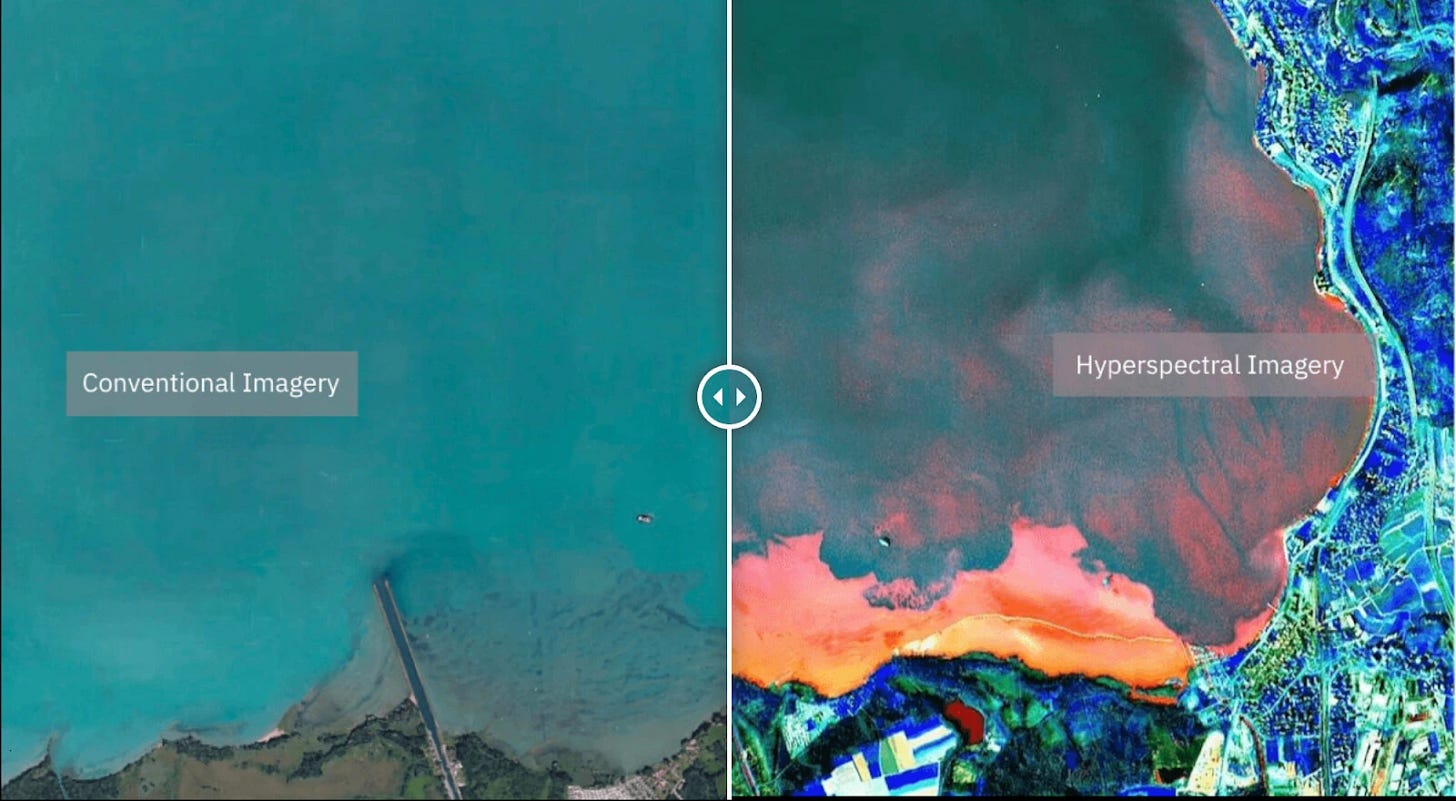
For more than half a century, the Earth Observation (EO) economy has rested upon a structural compromise: the visual paradigm. Orbital imaging constellations, spanning from national space agency flagships like Landsat to commercial ventures such as Planet Labs and Maxar Technologies, have historically operated within the narrow bounds of multispectral imaging. By capturing reflected sunlight across a handful of broad color bands—primarily red, green, blue, and standard near-infrared—these platforms generate high-fidelity, aesthetic maps. They photograph the surface of the planet; they record what the human eye would see if suspended in low-Earth orbit (LEO).
Yet for institutional enterprise asset allocators, agricultural conglomerates, sovereign resource ministries, and energy underwriters, knowing what the surface looks like is no longer sufficient. It provides an incomplete balance sheet of physical reality. A pipeline corridor may appear pristine in high-resolution RGB imagery while leaking hundreds of metric tons of invisible, odorless methane per hour into the atmosphere. A commercial monoculture soybean field in Mato Grosso may display lush green canopies on traditional satellite indices while silently starving from subterranean nitrogen deficiencies or fungal spores that will decimate yield margins three weeks later.
This information asymmetry represents the market opening for Pixxel, the space-tech startup founded in 2019 by BITS Pilani alumni Awais Ahmed and Kshitij Khandelwal. Pixxel’s core thesis rejects optical cartography in favor of orbital chemical spectroscopy. By deploying bespoke, miniaturized hyperspectral sensors capable of dividing the electromagnetic spectrum into hundreds of narrow, continuous spectral bands, the company is systematically building an orbital engine designed not merely to photograph Earth, but to run real-time molecular diagnostics on its biosphere.
“The transition from multispectral to hyperspectral is conceptually equivalent to moving from an exterior photograph of a patient to an internal magnetic resonance imaging (MRI) scan,” notes an aerospace systems analyst familiar with Pixxel’s orbital architecture. “Multispectral tells you there is a forest or a factory; hyperspectral tells you the exact cellular hydration of the canopy, the species of the timber, the heavy-metal toxicity in the runoff pond, or the concentration of fugitive hydrocarbons leaking from an unlit flare stack. That is the delta between visual tracking and predictive financial underwriting.”
The Balance Sheet Transformation: From Deep Tech to Downstream SaaS

Building, testing, launching, and operating a proprietary constellation of low-Earth orbit satellites is one of the most capital-intensive endeavors in modern venture capitalism. In its nascent phases, Pixxel faced the steep unit economics typical of early NewSpace ventures: high launch costs, satellite payload development cycles extending over years, and the omnipresent threat of launch vehicle failure. However, the macro-environment has inverted in Pixxel’s favor, propelled by two secular trends: the dramatic decline in per-kilogram launch costs catalyzed by commercial rideshare operators, and the convergence of off-the-shelf optical instrumentation with proprietary optical fabrication.
Pixxel’s funding trajectory reflects institutional endorsement of this structural shift. Having raised capital across successive rounds from early backers like Blume Ventures and growX ventures to global tier-one institutional vehicles such as Lightspeed India, Radical Ventures, and strategic corporate capital from Google’s India Digitization Fund, Pixxel has mobilized substantial growth capital. The firm's capitalization runway, now approaching and pacing toward the $100 million cumulative threshold across debt, equity, and strategic grants, provides the balance-sheet liquidity required to clear the operational chasm separating proof-of-concept orbital testing from commercial scale.
Critically, the enterprise valuation multiples of Earth Observation companies are no longer determined by the gross mass of metal hoisted into space, but by the downstream recurring revenue derived from orbital data. The historic bankruptcy filings and equity devaluations of legacy satellite operators serve as a cautionary tale: infrastructure without high-margin software monetization yields poor capital efficiency. Pixxel’s strategic initiative centers on transforming its orbital telemetry into an enterprise platform called Aurora—an analytics engine engineered to ingest petabytes of hyper-dimensional raw radiance arrays, ingest radiometric and geometric corrections on automated cloud pipelines, and distribute automated predictive signals directly into enterprise ERP and commodity trading workflows.
By positioning the constellation as the upstream data engine for an integrated API ecosystem, Pixxel aims to capture software-as-a-service (SaaS) gross margins exceeding 75%, insulating its operating model from the depreciating CapEx cycles inherent to aerospace hardware maintenance.
The Technical Architecture of the Hyperspectral Engine
To grasp the technical barrier to entry Pixxel has erected, one must analyze the physical challenges of spatial and spectral trade-offs. In orbital sensor design, physics imposes a rigorous zero-sum game: an optical engineer can maximize spatial resolution (the size of a pixel on the ground), spectral resolution (the narrowness and quantity of light wavelengths captured), or temporal resolution (the frequency with which a satellite revisits a specific coordinate on the surface).
Legacy government satellites prioritized spectral fidelity at the expense of commercial utility. Instruments like NASA’s airborne AVIRIS or the European Space Agency’s PRISMA constellation demonstrated the scientific efficacy of hyperspectral analytics, but suffered from 30-meter ground sample distances (GSD) and revisit rates stretching across weeks. Conversely, venture-backed commercial imaging fleets prioritized sub-meter spatial resolution, but abandoned spectral granularity, restricting sensors to 4 to 8 wide optical bands.
Pixxel’s engineering breakthrough, demonstrated on its precursor technology demonstration satellites—including Shakuntala (TD-2) launched aboard a SpaceX Falcon 9 Transporter mission and Anand (TD-1)—lies in miniaturizing a high-throughput, high-signal-to-noise-ratio (SNR) hyperspectral optical payload capable of fitting into a microsatellite chassis. Pixxel’s commercial operational tier, dubbed the "Fireflies" constellation, is engineered to bridge these historically incompatible domains: delivering 5-meter ground spatial resolution across dozens to hundreds of narrow bands within the Visible to Near-Infrared (VNIR) and Short-Wave Infrared (SWIR) spectrums, paired with a high-cadence global revisit capability.
Comparative Architecture: The Earth Observation Spectrum
The strategic deployment of hyperspectral sensors rewrites the competitive map for orbital intelligence providers. The following comparative data models the generational leap represented by Pixxel's target architecture against legacy paradigms:
| Operational Metric | Conventional Multispectral (Commercial) | Legacy Hyperspectral (Institutional) | Pixxel Constellation (Fireflies / Aurora) |
|---|---|---|---|
| Spectral Bands | 3 to 12 Broad Bands | 200+ Contiguous Bands | Up to 250+ Contiguous Bands |
| Ground Sampling (GSD) | 0.3m – 3.0m (High Spatial) | 30m (Low Spatial) | 5m (High Hyperspectral Resolution) |
| Spectral Range | VNIR (400–900 nm) | VNIR to SWIR (400–2500 nm) | VNIR + SWIR Integrated Payloads |
| Primary Commercial Focus | Cartography, Defense Surveillance, Infrastructure Assets | Scientific Research, Climatology, Academic Geoscience | Commodity Diagnostics, ESG Audits, Mining, Carbon Credit Validation |
| Revisit Cycle | Sub-Daily to Daily | 14 to 30 Days | Daily (Full Constellation Scale) |
Macro Implications: Who Wins, Who Loses, and Enterprise ROI
The downstream consequences of deploying hyperspectral capabilities at scale will trigger disruption across multiple legacy industrial verticals:
1. Commodity Underwriting and Precision Agriculture
Traditional agricultural monitoring relies heavily on NDVI (Normalized Difference Vegetation Index), a crude mathematical ratio calculated using red and near-infrared reflectance. NDVI alerts an agronomist that a field is undergoing vegetative stress only after cellular chlorophyll degradation has progressed to visual wilting. Pixxel’s hyperspectral telemetry detects canopy-level nitrogen, phosphorus, moisture content, and early enzyme shifts. Large-scale enterprise agribusinesses like Corteva or Bayer, alongside macro-soft commodity trading desks at Cargill and Glencore, can model real-time global crop output variations weeks before standard USDA reports are formulated. The "winners" are quantitative traders and precision fertilizer operators; the "losers" are legacy agronomic consulting firms relying on manual, ground-level sampling and trailing indicators.
2. The Extractives Sector: Mining, Exploration, and Upstream Hydrocarbons
In modern mineral discovery, the easily accessible surface reserves of critical green-transition metals—lithium, nickel, copper, and cobalt—have largely been depleted. Exploration outfits face skyrocketing exploratory drilling costs with diminishing success rates. Hyperspectral imaging fundamentally re-engineers the front end of the mining capital deployment funnel. By mapping the unique absorption signatures of alteration minerals (such as gossans, carbonates, and phyllosilicates) that envelop subterranean ore bodies, Pixxel can screen vast unmapped jurisdictions at a fraction of the cost of seismic and low-altitude airborne surveys. Exploration budgets can be allocated exclusively to mathematically validated target anomalies, reducing exploratory CapEx burn rates by double-digit percentages.
3. Real-Time Regulatory Compliance and ESG Asset Underwriting
The regulatory apparatus surrounding industrial environmental footprints has fundamentally shifted from self-reported corporate disclosures to verifiable, adversarial surveillance. With the implementation of the European Union’s Corporate Sustainability Due Diligence Directive (CSDDD) and tightening SEC disclosure guidelines on scope 1 and 2 emissions, corporations face material legal, financial, and reputational liability for unmitigated emissions. Fugitive methane emissions are particularly perilous; methane carries a global warming potential more than 80 times that of carbon dioxide over a 20-year horizon. Pixxel’s short-wave infrared channels can isolate the specific absorption fingerprints of methane plumes venting from compression stations, pipeline flanges, or inactive oil wells globally, transforming compliance verification into an empirical, inescapable real-time data layer.
Frequently Asked Questions (People Also Ask)
How does Pixxel’s hyperspectral imaging fundamentally differ from standard commercial satellite imagery?
Standard commercial satellites utilize multispectral optical sensors that capture electromagnetic reflection across 3 to 8 broad bands of the spectrum (such as red, green, blue, and broad near-infrared), effectively delivering high-definition photographs of physical features. Pixxel’s hyperspectral sensors divide the spectrum into dozens to hundreds of narrow, continuous, contiguous wavelength channels. This enables the sensor to measure the precise molecular absorption and reflectance profiles of matter, identifying chemical composition, cellular health, gas emissions, and mineral deposits that are invisible to optical cameras.
What enterprise use cases drive the monetization of Pixxel's data?
Pixxel monetizes its orbital data across several primary commercial verticals:
- Agriculture: Real-time assessment of crop nutrient deficits, pathogen infestation, and soil organic carbon content long before physical symptoms appear.
- Mining and Critical Minerals: Rapid, cost-effective geological mapping of mineral alteration zones for lithium, copper, gold, and rare earth deposits.
- Energy Infrastructure: Precise spatial pinpointing and volumetric tracking of fugitive methane emissions and oil spills across distribution networks.
- Environmental and Carbon Accounting: Independent, empirical verification of terrestrial carbon sequestration projects, deforestation risks, and corporate ESG compliance.
Who are Pixxel’s primary institutional and strategic backers?
Pixxel’s capitalization table includes top-tier venture firms and institutional technology conglomerates. Key investors include Google (via its India Digitization Fund), Radical Ventures (a leading global artificial intelligence investment firm), Lightspeed India, Blume Ventures, growX ventures, and Sparta Group. This investor syndicate combines deep space hardware capital, AI-centric enterprise software expertise, and balance-sheet capacity to underwrite multi-year constellation deployment programs.
What is the Aurora platform, and why is it critical to Pixxel's business model?
Aurora is Pixxel’s proprietary enterprise software platform designed to democratize and analyze raw hyperspectral data. Hyperspectral data sets are massive, hyper-dimensional arrays (often called data cubes) that require specialized processing to correct for atmospheric distortion, sensor angle, and solar geometry. Aurora automates this data transformation, extracting key analytical insights, indexes, and predictive alerts. Instead of requiring customers to hire specialized PhD remote-sensing scientists, Aurora allows enterprises to integrate direct analytical outputs via standard APIs into their native operational and risk management dashboards.
Future Outlook: The Sovereign Race to Map the Invisible
The next 24 to 36 months will represent the critical crucible for Pixxel’s operational thesis. As the startup executes its multi-satellite launch campaigns, the central challenge transitions from orbital physics to infrastructure integration: the rapid scaling of ground station downlink bandwidth, low-latency edge-compute orchestration, and the retention of enterprise accounts against both legacy aerospace primes and well-funded emerging orbital observation peers.
The macro-geopolitical environment will increasingly act as a growth tailwind. As governments across the Global North and the Indo-Pacific prioritize supply-chain sovereignty for critical raw materials, real-time spatial intelligence regarding global mineral deposits, sovereign agricultural yields, and emissions tracking will become a matter of national security. Space is no longer solely a domain for sovereign exploration; it has evolved into the definitive operating system for terrestrial asset management.
By transforming raw solar reflection into an immutable diagnostic ledger of the planet’s vital signs, Pixxel is constructing more than a satellite fleet. It is engineering the predictive nervous system of global commerce. For enterprise boardrooms and sovereign leaders navigating climate volatility, resource scarcity, and aggressive regulatory shifts, the question is no longer whether they can afford to access high-frequency hyperspectral intelligence. The question is whether they can survive without it.