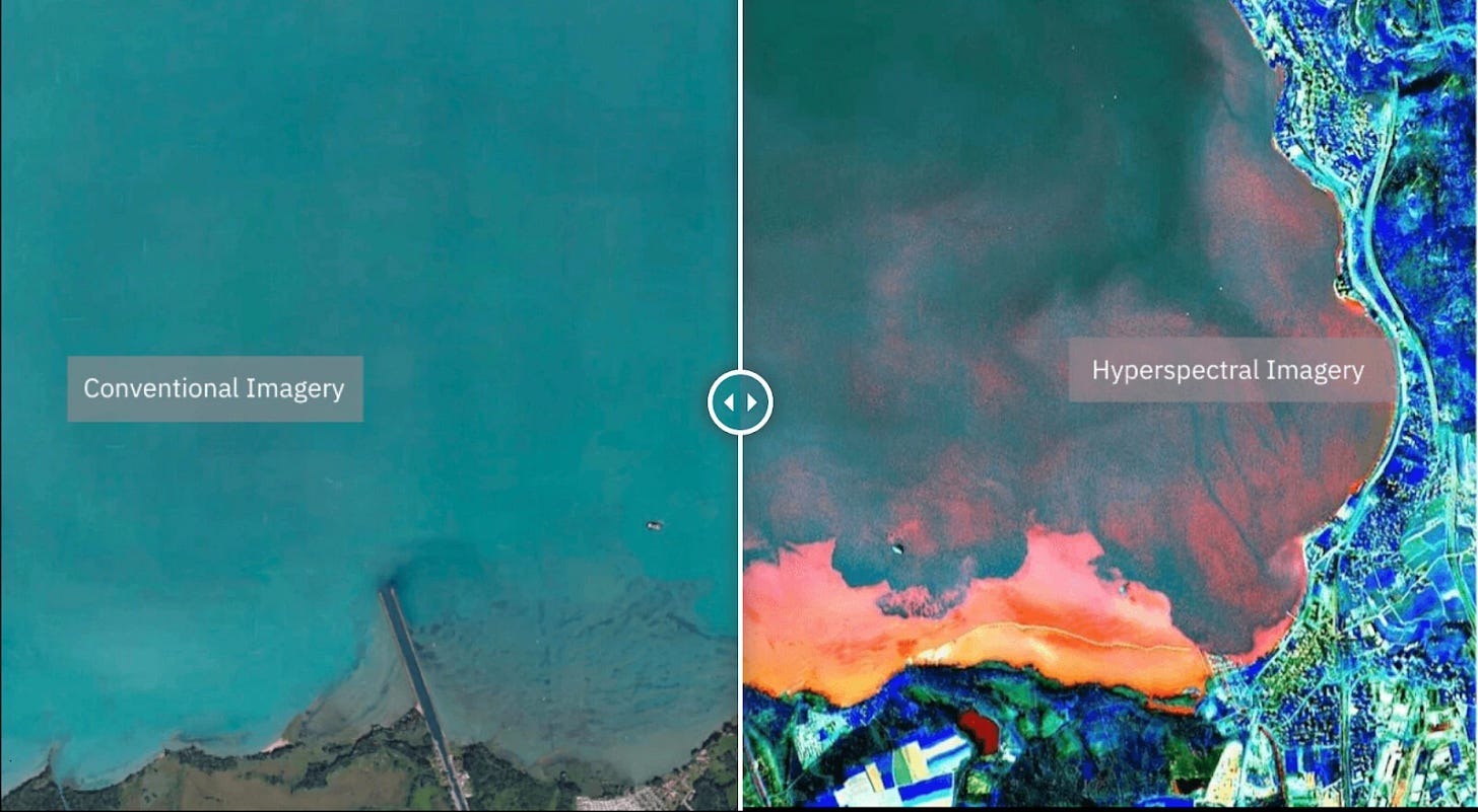
Executive Takeaways
- Hyperspectral Dominance: Pixxel is moving commercial satellite imaging beyond traditional RGB bands into advanced hyperspectral imaging, capturing hundreds of narrow contiguous spectral bands to reveal invisible chemical and biological signatures.
- Capital Infusion & Valuation: Backed by a strategic $36 million Series B funding round—part of over $100 million in total capital raised—the startup is aggressively scaling its satellite constellation architecture and cloud-based analytics engine.
- Enterprise ROI & Market Shift: By unlocking granular data for agriculture, mining, and environmental compliance, Pixxel is transforming Earth observation from a government-led intelligence tool into a high-margin enterprise software-as-a-service (SaaS) input.
For decades, commercial Earth observation (EO) has suffered from a fundamental resolution paradox: we could see the forests, but we couldn't read the leaves. Standard optical satellites operated much like consumer digital cameras, capturing red, green, and blue (RGB) wavelengths. While sufficient for tracking urban sprawl or broad deforestation, these systems remained blind to the molecular composition of the terrain beneath them. They could spot a pipeline leak *after* soil degradation turned the canopy brown, but they could never preemptively detect the anomalous hydrocarbon seepage in the soil beforehand.
Enter Pixxel. Founded by CEO Awais Ahmed and co-founder Khandelwal when they were still college undergraduates, the Bengaluru- and Los Angeles-based hyperspectral imaging pioneer is orchestrating a paradigm shift in space-based intelligence. With a war chest exceeding $100 million in cumulative equity financing—anchored by a pivotal $36 million Series B round featuring heavyweights like Google, Radical Ventures, Lightspeed Venture Partners, and Blume Ventures—Pixxel is transitioning from a proof-of-concept hardware startup into a mission-critical infrastructure provider for global enterprises.
As capital allocation priorities across venture and institutional markets shift toward profitable, hard-tech infrastructure, Pixxel’s trajectory offers a masterclass in risk mitigation, technological moats, and enterprise monetization in the New Space economy.
The Hyperspectral Edge: Moving From Seeing to Understanding
To comprehend Pixxel’s market disruption, one must understand the limitations of legacy remote sensing. Standard multispectral satellites typically capture between four and twelve spectral bands. Hyperspectral imaging, by contrast, captures hundreds of contiguous narrow bands across the electromagnetic spectrum—from visible light to short-wave infrared. Each pixel in a Pixxel image is effectively a detailed high-resolution spectrometer reading.
This technological leap unlocks entirely new categories of enterprise ROI. Where a traditional satellite sees a standard agricultural field, Pixxel’s Firefly and Honeybee constellations can detect:
By transforming raw electromagnetic reflections into actionable business intelligence, Pixxel is positioning itself not merely as a data provider, but as a foundational input for enterprise cloud compute architectures and geographic information systems (GIS).
Capital Allocation and Infrastructure Scalability

Scaling a space-tech enterprise requires navigating extreme capital intensity alongside severe technical risk. Building, testing, and launching constellations of advanced micro-satellites demands rigorous cash burn management and sophisticated financial engineering.
Pixxel’s recent funding milestones reflect deep institutional confidence in its infrastructure scalability. With over $100 million secured, the company has methodically deployed capital across three core pillars:
- Constellation Expansion: Manufacturing and launching a planned network of hyperspectral satellites designed to provide daily global coverage and unprecedented revisit rates.
- Talent Acquisition: Recruiting top-tier aerospace engineers, optical physicists, and machine learning specialists across its offices in India and the United States.
This disciplined capital allocation has allowed Pixxel to compress development cycles drastically compared to legacy defense contractors, achieving high-cadence iteration akin to modern Silicon Valley software firms.
Verified Data & Metrics Breakdown
The following metrics highlight Pixxel’s financial trajectory, technological specifications, and market positioning within the global Earth observation sector:
| Metric Category | Pixxel Specification / Data Point | Industry Benchmark / Comparison |
|---|---|---|
| Total Capital Raised | Over $100 Million (Cumulative) | Top 5% of global New Space venture capital rounds |
| Key Funding Catalyst | $36 Million Series B (Led by Google, Radical Ventures) | Validates institutional appetite for commercial hyperspectral data |
| Spectral Resolution | 350+ contiguous bands (Visible to SWIR) | Standard commercial optical satellites: 4 to 12 bands |
| Spatial Resolution | Up to 5-meter resolution | Historically restricted to costly government reconnaissance assets |
| Primary Target Markets | Agriculture, Energy, Mining, Defense, Environmental Monitoring | Expanding from defense-heavy reliance to high-margin commercial enterprise |
Industry & Market Implications: Winners and Losers
Pixxel’s maturation signals a broader structural rotation in the global space economy. For decades, high-resolution hyperspectral and radar intelligence was the exclusive domain of sovereign defense agencies and intelligence communities. Commercializing this capability creates profound ripple effects across multiple asset classes:
The Winners
The Losers
Frequently Asked Questions (People Also Ask)
What is hyperspectral imaging and how does it differ from standard satellite imagery?
Standard satellite imagery captures light in three to four primary color bands (Red, Green, Blue, and Near-Infrared), much like a standard digital camera. Hyperspectral imaging captures hundreds of narrow, contiguous spectral bands across the light spectrum. This allows analysts to identify the unique chemical and material "fingerprint" of objects on Earth's surface—such as specific minerals, water contaminants, or plant health metrics—that are completely invisible to standard cameras.
Who are Pixxel’s primary investors and how much capital have they raised?
Pixxel has raised over $100 million in total funding. Key institutional backers include Google, Radical Ventures, Lightspeed Venture Partners, Blume Ventures, and Omnivore. Their $36 million Series B round accelerated the manufacturing and deployment of their commercial satellite constellations.
How do enterprises monetize Pixxel’s Earth observation data?
Enterprises integrate Pixxel’s data feeds into their geographic information systems (GIS) and analytics platforms to drive operational efficiencies. Use cases include detecting underground pipeline leaks before failures occur, optimizing fertilizer and water usage in commercial agriculture, auditing carbon and methane emissions for ESG compliance, and locating rare earth minerals for mining operations.
When was Pixxel founded and who leads the company?
Pixxel was founded in 2019 by Awais Ahmed (CEO) and Khandelwal while they were undergraduate students in India. The company now maintains a dual-headquarters structure spanning Bengaluru, India, and Los Angeles, California.
Future Outlook: Milestones to Watch
As Pixxel transitions from initial constellation deployment to full commercial scale, market observers and institutional investors will closely monitor several key catalysts over the next 12 to 24 months:
Pixxel’s journey from undergraduate concept to a hundred-million-dollar geospatial powerhouse illustrates the profound economic potential unlocked when deep-tech innovation meets targeted enterprise demand. By moving humanity past mere visual observation into true molecular understanding of our planet, Pixxel is rewriting the operating manual for global resource management.