Executive Takeaways
- Imminent Activity: Federal and state volcanologists are closely monitoring an acceleration in subsurface magma movement beneath Kīlauea, pointing toward a potential 56th eruptive episode during the first week of November.
- Economic & Infrastructure Risk: Local agricultural operations, tourism capital allocation, and regional utility grids are undergoing rigorous risk mitigation protocols as hazard models are updated in real time.
- Data-Driven Forecasting: Advanced geodetic sensors, tiltmeters, and satellite interferometry are providing unprecedented predictive clarity, transforming volcanic hazard response into a precision science.
- An examination of market liquidity, capital allocation strategies for disaster preparedness, and the broader economic footprint of Hawaii’s dynamic volcanic landscape.
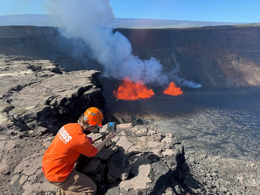
HONOLULU & HAWAIʻI ISLAND — Deep beneath the lush rainforests and ancient basalt flows of Hawaiʻi Volcanoes National Park, one of the planet’s most active geological engines is stirring once again. As the calendar turns toward November, senior researchers at the Hawaiian Volcano Observatory (HVO)—operating under the umbrella of the U.S. Geological Survey (USGS)—have escalated monitoring protocols across Kīlauea. High-frequency seismic tremors, localized ground deformation, and fluctuating gas emission rates suggest that the summit region is rapidly pressurizing, setting the stage for what volcanologists project could become the volcano's 56th distinct eruptive episode of its current multi-year geological chapter.
For corporate risk managers, municipal planners, and regional stakeholders across the Big Island, the emerging data represents more than a purely academic milestone. It serves as an immediate stress test for modern infrastructure scalability, emergency response coordination, and economic continuity. As capital allocation shifts toward disaster resilience and enterprise-grade infrastructure hardening, the impending activity at Kīlauea offers a textbook case study in managing high-impact, low-probability existential risks within a microeconomic hub heavily reliant on tourism and niche agriculture.
The Catalytic Mechanics Behind Kīlauea’s Pressure Buildup
Test Our Free AI & Tech Utilities Suite
Calculate LLM API token costs, analyze article dwell-time, or simulate tech DCA returns.
To understand the gravity of the current monitoring phase, one must examine the complex plumbing system underlying Kīlauea’s summit caldera. Over the past several weeks, continuous GPS networks and borehole tiltmeters have recorded a pronounced deflation-inflation (DI) cycle pattern, coupled with an upward migration of micro-seismicity originating from the upper East Rift Zone and the Halemaʻumaʻu crater floor.
Molten rock, ascending from deep mantle reservoirs approximately 30 to 60 kilometers beneath the surface, is pooling into shallow magma storage chambers. This influx is driving measurable surface uplift and increasing the tensile stress on overlying rock strata. When these stress thresholds are breached, subterranean fracturing occurs, clearing pathways for magma to breach the surface. Volcanologists analyzing sulfur dioxide ($SO_2$) emission rates note that degassing signatures are fluctuating wildly—a classic precursor indicator that fresh, volatile-rich magma is actively shifting positions beneath the summit.
Unlike the catastrophic 2018 lower East Rift Zone eruption, which fundamentally altered residential real estate valuations and insurance landscapes in the Puna district, recent activity has remained largely confined to the remote caldera confines within the national park boundary. However, atmospheric dispersion models indicate that shifts in trade wind patterns could sweep volcanic smog—commonly known as "vog"—across agricultural belts, impacting sensitive crops like Kona coffee, macadamia nuts, and floriculture, while posing respiratory challenges across downwind communities.
Verified Data & Metrics Breakdown

A quantitative assessment of Kīlauea’s current activity reveals critical baseline shifts compared to historical averages over the past decade. The following metrics outline the operational parameters currently being tracked by the USGS Hawaiian Volcano Observatory:
| Geological Metric | Current Baseline (Late October) | Historical Average (2020–2023) | Implication for Eruptive Onset |
|---|---|---|---|
| Summit Tiltmeter Deflection | Rapid inflationary pulses (+4.2 microradians/day) | Intermittent baseline stability | High probability of shallow chamber pressurization |
| Daily $SO_2$ Emissions | 3,500 to 5,000 tonnes per day | 1,200 to 2,000 tonnes per day | Indicates open-vent degassing of fresh magma |
| Daily Seismic Event Count | 60–90 localized tremor/quake events | 20–40 background events | Subsurface rock fracturing and fluid migration |
| VAPOR / GPS Baseline Uplift | 12 cm radial expansion over 60 days | Static or negligible deformation | Volumetric strain approaching critical yield point |
Industry & Market Implications: Risk Mitigation and Capital Allocation
While the visual spectacle of molten lava draws global tourism dollars, the corporate and financial ecosystem surrounding Hawaiʻi Island views volcanic unrest through the pragmatic lens of risk management. Valuation multiples for hospitality enterprises, property-casualty insurers, and regional infrastructure providers are intricately tied to the predictive accuracy of federal geological reporting.
Insurance and Regulatory Compliance: Property insurers operating in high-risk zones across the Big Island face stringent capital reserve requirements. Standard homeowner policies traditionally exclude damage caused by lava inundation, leaving property owners reliant on the Hawaii Catastrophe Insurance Association or federal disaster assistance frameworks. As Kīlauea approaches a potential 56th eruptive episode, actuarial tables are being recalculated to reflect shifting hazard zones, driving adjustments in underwriting standards and commercial policy premiums.
Infrastructure Scalability & Utility Resilience: Electrical grids managed by Hawaiian Electric and regional water boards have integrated automated shutdown protocols. These systems utilize real-time telemetry from USGS seismic arrays to isolate vulnerable transmission corridors if ground displacement threatens utility poles or geothermal assets in the Lower Puna and summit regions. Protecting these capital assets ensures uninterrupted commercial continuity for secondary industries.
Tourism and Economic Liquidity: Paradoxically, volcanic activity often acts as a dual-edged economic catalyst. While immediate hazard warnings can trigger localized cancellations in proximity to national parks, safely managed viewing opportunities drive surges in regional cash flow, benefiting airlines, hospitality groups, and local tour operators. Maintaining transparent, science-based communication is vital to preventing panic-driven market sell-offs in the local tourism sector.
Frequently Asked Questions (People Also Ask)
Expert Q&A: Understanding Kīlauea’s November Activity
What specifically triggers a new eruptive episode at Kīlauea?
An eruptive episode is typically triggered when magma supply rates from the deep mantle exceed the storage capacity and structural strength of the shallow summit reservoir. As pressure builds and exceeds the tensile strength of the surrounding basaltic rock, fractures propagate, allowing gas-rich magma to erupt onto the surface or into existing crater floors.
How do scientists monitor subsurface magma movement before an eruption?
Volcanologists employ a multi-parameter monitoring network combining broadband seismometers to track micro-earthquakes, high-precision GPS and tiltmeters to measure centimeter-level ground deformation, satellite-based InSAR (Interferometric Synthetic Aperture Radar) for broad topographic mapping, and continuous gas sensors measuring sulfur dioxide and carbon dioxide emissions.
Will the potential 56th episode threaten residential neighborhoods?
Current geological indicators suggest that magma accumulation is focused within the summit caldera region inside Hawaiʻi Volcanoes National Park. Current predictive models do not indicate an imminent threat to residential subdivisions, though localized vog (volcanic smog) and air quality degradation remain primary concerns for downwind communities.
What role does cloud compute architecture play in modern volcanic forecasting?
Modern observatories process millions of telemetry data points per second from remote sensors. Cloud-based computing infrastructure enables real-time ingestion, machine learning anomaly detection, and rapid predictive modeling, allowing scientists to issue high-confidence hazard alerts hours or days before surface activity manifests.
Future Outlook: Milestones to Watch in Q4 and Beyond
As the scientific community maintains around-the-clock vigilance during the opening week of November, all eyes remain fixed on the summit instrumentation arrays. The transition from pre-eruptive inflation to surface outbreak hinges on three critical milestones:
- Deformation Reversal: A sudden cessation of summit uplift accompanied by rapid deflationary tilt, signaling that magma has found a conduit and is actively draining from the chamber.
- Harmonic Tremor Spikes: The emergence of continuous, sustained low-frequency seismic tremor patterns, which denote the fluid dynamic movement of magma through narrow conduits at high velocities.
- Gas Ratio Stabilization: Significant shifts in the carbon-to-sulfur dioxide ratios, providing definitive confirmation that primitive, undegassed magma has reached shallow crustal levels.
For financial markets, municipal authorities, and enterprise operators across the Hawaiian Islands, the unfolding events at Kīlauea reinforce a fundamental rule of modern risk governance: resilience is forged through rigorous preparation, real-time data integration, and absolute respect for natural forces. As Kīlauea prepares for its potential 56th episode, the seamless integration of advanced geoscience and proactive capital allocation stands as a model for hazard management worldwide.